PGC News & Announcements (June 30, 2022)
Missed out on the newsletter via email? Sign up here! PGC’s Cole Kelleher Appointed as U.S. Representative to SCAGI The … Continue reading PGC News & Announcements (June 30, 2022)
Hello! Login

Missed out on the newsletter via email? Sign up here! PGC’s Cole Kelleher Appointed as U.S. Representative to SCAGI The … Continue reading PGC News & Announcements (June 30, 2022)
Documentary Details Atlas of a Changing Earth (ACE) is a short film that discusses how a new revolution in map … Continue reading Atlas of a Changing Earth Coming to the Big Screen
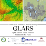
The PGC is excited to share with our partners from the Great Lake Alliance for Remote Sensing (GLARS) and SharedGeo … Continue reading Great Lakes Digital Surface Models Publicly Available
This position has been filled! Job Title: Graduate Research Assistant Location: Twin Cities Regular/Temporary: Regular Job ID: 347500 Job Code: … Continue reading Position Available: Graduate Research Assistant (Summer 2022) – Filled!
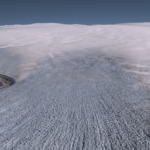
The Arctic Imagery Mosaic is updated and live! Our team of staff and students have spent hours of manual quality … Continue reading PGC Arctic Imagery Mosaic 2022 Update
The Polar Geospatial Center (PGC) is very excited to share honorable news that Cole Kelleher is the newly designated U.S. … Continue reading PGC’s Cole Kelleher Appointed as U.S. Representative to SCAGI
The PGC has learned a lot from users and researchers on how the ArcticDEM project enables innovative thinking and scientific … Continue reading Logan Earth – enhancing Google Earth with ArcticDEM for the NWT
PGC is excited to announce its newest allocation on Frontera, the largest academic supercomputer in the world located at the … Continue reading High-Resolution Geospatial Mapping with Frontera
Missed out on the newsletter via email? Sign up here! Ernest Shackleton’s Ship Found in Antarctica The recent discovery of … Continue reading PGC News & Announcements (March 31, 2022)
Missed out on the newsletter via email? Sign up here! PGC Welcomes Stephanie Linde We would like to extend a … Continue reading PGC News & Announcements (December 17, 2021)