PGC News & Announcements (June 30, 2022)

PGC News and Announcements

Missed out on the newsletter via email? Sign up here!


PGC’s Cole Kelleher Appointed as U.S. Representative to SCAGI

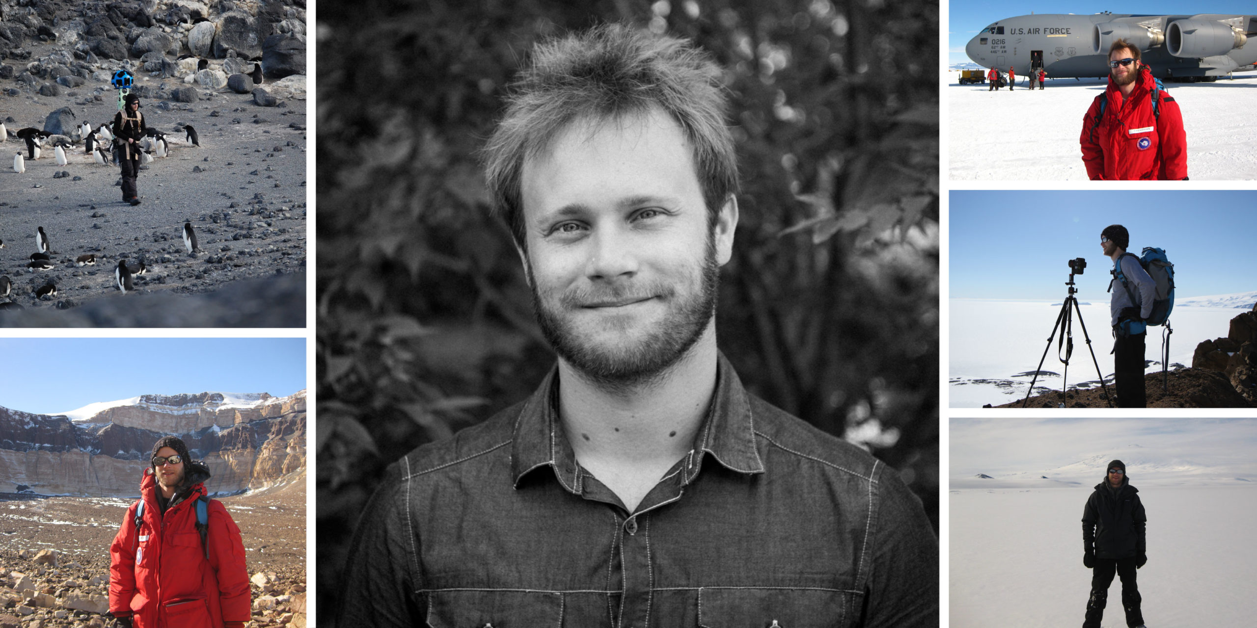
The Polar Geospatial Center (PGC) is very excited to share honorable news that Cole Kelleher is the newly designated U.S. representative to the international SCAR Standing Committee on Antarctic Geographic Information (SCAGI). This position was previously held by former PGC director, Paul Morin, who has stepped down. Kelleher’s designation maintains PGC’s prestige as a leader in Antarctic geospatial information, science, and support.

Kelleher first joined the PGC team in 2011 as a graduate student and has since evolved into the Center’s Satellite Tasking Coordinator. His role is critical for enabling remote sensing science and monitoring in areas of interest as well as advancing PGC’s efforts in creating high resolution digital elevation models from satellite stereoscopic imagery (ie. ArcticDEMREMA, and EarthDEM).

Kelleher’s passion is evident by his many accomplishments and contributions to Antarctic science support in addition to his 8 deployments to the Antarctic for the United States Antarctic Program (USAP). Other contributions include capturing imagery of the McMurdo Dry Valleys for Google Street View, producing the SCAGI Air Operations map series, and leading improvement efforts of Antarctic placename locations. Kelleher has been a member of SCAGI since 2018 and looks forward to continuing his commitment to accurate, accessible, and collaborative Antarctic data and research.


Great Lakes Digital Surface Models Publicly Available

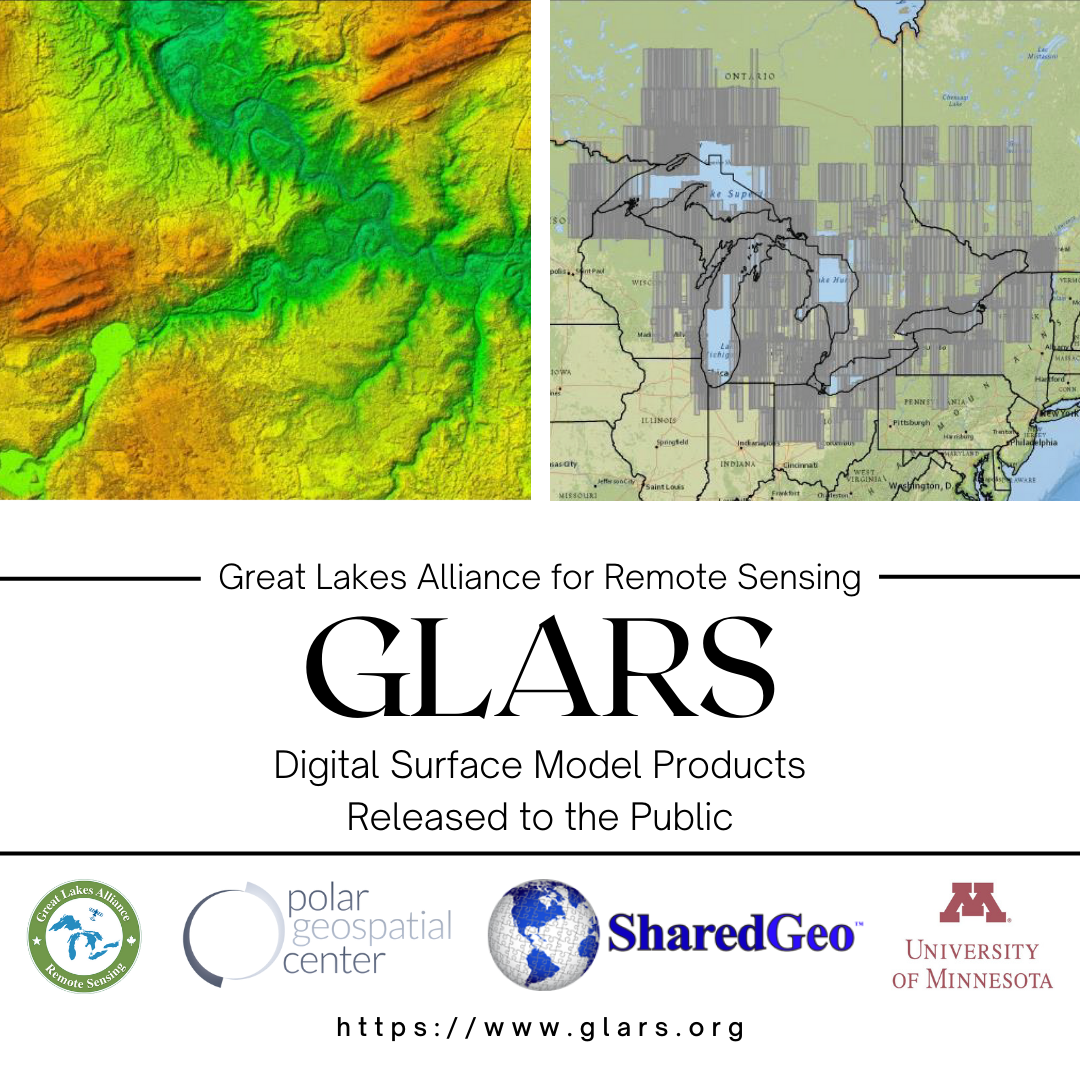
Last month, PGC shared alongside our partners from the Great Lake Alliance for Remote Sensing (GLARS) and SharedGeo, the exciting news regarding the public release of high-resolution digital surface models (DSMs) across the Great Lakes Basin. Now available for use by researchers, conservationists, natural resource managers and the public for free. The elevation dataset includes timestamped strips and seamless mosaics covering 85% of the basin at a 2-meter resolution, derived from Maxar stereo imagery.

It is the first public domain release of non-polar DSM products covering an expansive area and demonstrates potential for other units of government to use DSMs for modeling, monitoring, and managing environments without the high cost of LiDAR products.

HELPFUL LINKS:

SharedGeo GLARS press release

GLARS Data Viewer info page

PGC EarthDEM


Arctic Mosaic Update

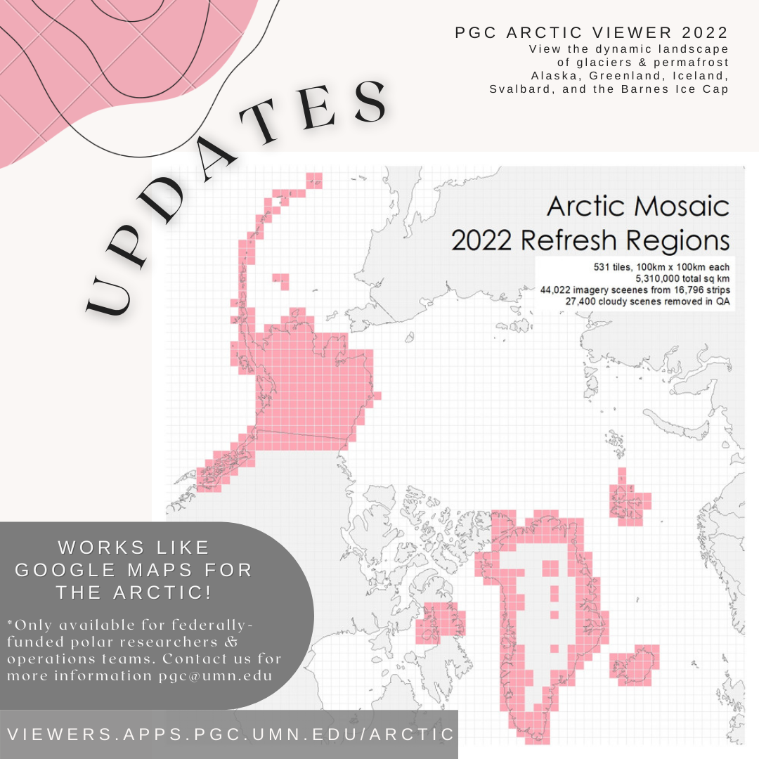
In case you missed it, our Arctic Imagery Mosaic was updated in April. Our team of staff and students have spent hours of manual quality assessment and processing to provide newer 50 cm imagery mosaics across high priority areas.

Update efforts cover 531 tiles (100 x 100km each) totalling 5,310,000 sqkm assembled from 44,022 imagery scenes, which 27,400 cloudy scenes removed during QA! New coverage has 81% of scenes collected between 2019-2021. Updated tiles were selected based on PGC User priority areas and satellite tasking requests, designed to refresh areas of highest interest from the community. Coverage in the update includes the Barnes Ice Cap in Canada, the full coast of Greenland, the islands of Iceland and Svalbard, and all of Alaska.

Due to licensing restrictions, the imagery mosaics are only available to federally-funded polar researchers, operations subcontractors, and federal employees with a PGC verified account required (detailed links below).

PGC users can access the data layers in desktop GIS (see guide below) or in our browser-based web-mapping application, the Arctic Viewer at https://viewers.apps.pgc.umn.edu/arctic.
HELPFUL LINKS:

PGC Imagery Viewers Guide

PGC Imagery Viewer Web Apps

Using PGC Web Mapping Services in GIS Desktop Guide

PGC Account Request

PGC Viewers Terms & Conditions


Antarctic Tasking Requests Due July 8, 2022

PGC is working with the National Geospatial-Intelligence Agency (NGA) to coordinate collections of high-resolution commercial satellite imagery from Maxar’s DigitalGlobe for the upcoming 2022-23 Antarctic field season.

Please get in touch with your PGC Point of Contact if you have federal funding and are conducting Antarctic research or providing Antarctic logistics support and would like to submit tasking requests for your area(s) of interest. The deadline for requests for the upcoming Antarctic field season is July 8th, 2022. 

If you submitted a request for a previous year and would like to have imagery collected for a future season contact your POC for resubmission.


PGC Student Vignette

PGC holds an important focus in fostering support and growth for GIS and computer science students. We consistently hit the jackpot with our student recruitment, and this summer has been no exception. Here is a highlight of our newest graduate research assistants, Diego and Chris, who are both international fulbright scholars and passionate about the environment and their position at PGC:

Diego Osorio

  1. Tell us about where you are from and one of the coolest (perhaps also underrated) things to do in your country.

I am Colombian. Something that almost no one knows here is that Colombia is the second most biodiverse country in the world, but in area, it is the most biodiverse country per square kilometer. We are first in the number of species of birds and orchids; second in plants, amphibia, butterflies, and freshwater fish; third in palms and reptiles; and fourth in mammals. So, ecotourism is one of the coolest things to do there.

  1. Tell us about your academic career, your Fulbright scholarship, and how you got into your research/studies.

I studied a B.S. in environmental engineering at the Universidad de los Andes (Colombia) thanks to a 100% merit-based government scholarship. After graduating, I started working on a research project doing a land cover classification of South American paramos (tropical-alpine ecosystems located in the Andes over 2800 m.a.s.l.) and there I realized I was passionate about GIS and remote sensing. So, I applied for the Fulbright scholarship to pursue a master’s in spatial sciences in the U.S.

  1. What was the most surprising thing you did or saw since being in the USA?

I can mention several things that have surprised me here that are different from my country like using debit/credit cards to pay for everything instead of cash or the huge size of meals and food portions, but the most surprising thing was to see so many churches with the LGBTIQ+ flag and claiming to support the community. In Colombia, churches are traditional and conservative and they very often see LGBTIQ+ people as sinners.

  1. Why did you choose to work at PGC?

This position is completely related to my field. Here, I see the opportunity to apply my knowledge of and continue to learn about remote sensing, programming, GIS, among others, but also expand my academic and professional network. Likewise, it is very cool to learn about polar ecosystems.

  1. Where do you see yourself in 5 years from now?

I see myself working with a prestigious GIS corporation tackling projects related to environmental monitoring.

  1. Outside of your academic studies, what other interests do you enjoy?

I like to exercise: I try to work out 3-4 times a week, but also enjoy running, swimming, dancing, playing squash, hiking, and I just started learning to play tennis. Likewise, I fancy going on extreme rides and practicing extreme sports: what a good way to feel you are alive.

  1. What is one interesting fact you want people to know about you?

My friends and family know that my favorite hobby is eating. I love it! I like to try different cuisines and here I have had the opportunity to have dishes from different parts of the world. By the way, I am an ice cream lover.

Chris Carter

  1. Tell us about where you are from and one of the coolest (perhaps also underrated) things to do in your country.

I’m from Whitstable, a seaside town in Kent, England, about an hour outside of London by train. It’s a lovely place with great beaches and even greater seafood – be sure to give the oysters a try if you’re ever in the area! I grew up by the sea and Minnesota is by far the furthest I’ve ever lived from the ocean.

  1. Tell us about your academic career, your Fulbright scholarship and how you got into your research/studies.

I have a degree in Geophysics from Imperial College London which introduced me to the broad, diverse world of Earth Science and climatology. I learnt a lot about the science behind and the evidence for the climate crisis, but discussions always stopped frustratingly short of what we could actually do about it.

So I moved to Minnesota to undertake a Master’s in Science, Technology and Environmental Policy at the Humphrey School. Policy work is super different here in the US; it’s much more focused on quantitative work, which is where my strengths and interests lie, so the opportunity to study STEP in the US on a Fulbright scholarship is one I simply couldn’t pass up.

  1. What was the most surprising thing you did or saw since being in the USA?

The sheer scale of everything here is kinda crazy! Everything is bigger; the cars, the roads, the stores, the national parks… It’s taken some getting used to, especially coming from a city as dense and tightly-packed as London.

I also loved flying into Minnesota for the first time and seeing all the lakes from above – you really begin to understand where the ‘Land of 10,000 Lakes’ nickname comes from!

  1. Why did you choose to work at PGC?

The position at PGC is the perfect blend of my past and my current academic fields. Working with PGC helps me stay connected to the Earth Sciences, giving me the opportunity to work directly with scientists and researchers to further their fantastic work. And, as we all know, the polar regions are especially sensitive to changes in the climate, which links the work of PGC nicely to my current academic work in environmental policy.

  1. Where do you see yourself in 5 years from now?

That’s a tough question! After grad school I plan to move back to the UK, and continue my work in environmental policy, hopefully in a position that lets me put my GIS skills to good use.

  1. Outside of your academic studies, what other interests do you enjoy?

Minneapolis has really converted me to a beer-drinker, so I’m having a blast making my way round the Twin Cities’ many breweries! In the winter I love to downhill ski and I’m a trained scuba diver. I’m also due to adopt a kitten in a few weeks, so I’m eagerly preparing to become a parent.

  1. What is one interesting fact you want people to know about you?

I have a twin sister and I’m colour blind!

In Other News

Logan Earth app: Logan Rudkevitch, the creator of Logan Earth (loganearth.com), of Métis and Wiikwemkoong ancestry born and raised in Yellowknife, recognized communities in the north are poorly served by the southern focus of Google Earth and used the high resolution ArcticDEM mosaic tiles to enable a 3d view of the NWT. Learn more here.

CIRES PSECCO launch: The Cooperative Institute for Research in Environmental Sciences at the University of Colorado, Boulder (CIRES) has launched a Polar Science Early Career Community Office (PSECCO) to support community building and organization. Learn more here.

US-SCAR Scientists Directory: The U.S. Scientific Committee on Antarctic Research (SCAR) is building a comprehensive database of scientists involved in the U.S. Antarctic Program (USAP) and serve as a resource for new proposers, networking, and for general public understanding. Add your name to the directory here.


Check out the original PGC Newsletter post here.

Check out the original PGC Newsletter post here.

Leave a Reply