
Aerial Photography
Antarctic and Arctic imagery collected from low-altitude aircraft spanning from the 1950s to present day.
Introduction
Aerial photography (also called air photos) is remotely-sensed imagery taken from low-flying aircraft using sophisticated high resolution camera systems.
Aerial photography is not satellite imagery. Satellite imagery, such as Landsat or Quickbird, is taken from a spacecraft orbiting the earth.
Typically, aerial photography collected on campaigns of small geographic areas and collected over several days to weeks.
Aerial Photography Campaigns
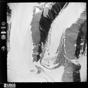
McMurdo Dry Valleys
Access Data
DOCUMENTATION
Antarctic LiDAR and Airphoto Campaign (2014-2015)
Background
Under NSF Award 1246342, Principal Investigator Andrew Fountain (Portland State University) led a campaign to collect high resolution LiDAR and aerial photography for the McMurdo Dry Valleys in Antarctica. The campaign was conducted by the NSF’s National Center for Airborne Laser Mapping (NCALM). The campaign flew for several weeks in December 2014 and January 2015.
EFFORTS
The LiDAR is available on the PGC Elevation page or from OpenTopography. Aerial photography is now available via the PGC HTTP Server. Web maps are forthcoming from PGC in 2024.
Antarctic TMA
Access Data
INDEXES
- TMA Flightlines (Esri shapefile)
- TMA Photocenters (Esri shapefile)
Documentation
Antarctic Single Frames (1946-2000)
Background
From 1946 to 2000, the U.S. Navy collected black and white trimetrogon aerial (TMA) photography of Antarctica. TMA photography is a camera system that collects a left-oblique, on-nadir (straight down), and right-oblique static frame.
The aerial photography was used for early topographic mapping efforts (including the USGS 1:250,000 scale map series). Today, they provide an historical snapshot of many parts of Antarctica.
Read more on the USGS website.
Efforts
The PGC and the USGS EROS Data Center in Sioux Falls, S.D. have collaborated to digitize and geolocate over 330,000 single-frame aerial photographs from the campaign.
EROS scanned the collection and PGC offers high, medium, and low resolution versions of the photographs.
The PGC has also digitized the flightlines and approximate photocenters to allow for a spatial search of the data.
Naming Scheme
To browse to individual flightlines, it is important to understand the USGS naming scheme.
- TMA flightline number is identified by the first 4 numbers of in the file/folder name, regardless of the letters that precede them (ABCA, ABC, or CA)
- V, R, and L in the file/folder name designate the orientation of the camera: vertical, right, and left, respectively
- The last 4 numbers in the file name designates the frame number (photocenter) along the flightline.
- The higher numbered flightlines are typically the most recent
Alaska AHAP
Access Data
INDEXES
- AHAP Flightlines (Esri shapefile)
- AHAP Photo Extents (Esri Shapefile)
Documentation
Alaska High Altitude Photography (1978-1986)
BACKGROUND
The Alaska High Altitude Photography (AHAP) campaign covers approximately 95% of the State of Alaska in 1:60,000 color infrared (CIR) and 1:120,000 black and white photography.
Approximately 60,000 frames of photography were acquired between 1978 and 1986 and recently scanned by the USGS EROS Data Center at medium resolution (400 dpi).
EFFORTS
The PGC is using an automated method to georeference approximately 90% of the AHAP data. The imagery is not accurately placed nor orthorectified. Errors can be up to 500 meters. However, the georeferenced versions are not yet available.
This georeferencing method is intended for approximation only. If more accurate registration is required, the user should find ground control points for each image.