Important License Update
As of June 15, 2022, Maxar Technologies transitioned from the NextView License to the Electro-Optical Commercial Layer (EOCL) License. The … Continue reading Important License Update
Hello! Login

As of June 15, 2022, Maxar Technologies transitioned from the NextView License to the Electro-Optical Commercial Layer (EOCL) License. The … Continue reading Important License Update
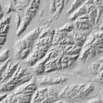
Revolutionizing Arctic Topography Mapping: ArcticDEM Mosaic Release 2023 [Twin Cities, 08/17/2023] – The Polar Geospatial Center (PGC) at the University … Continue reading ArcticDEM Mosaic 4.1 Release August 2023
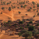
Beyond the Poles PGC aided NASA researchers in leveraging satellite imagery to produce a census of trees across the Sahara. … Continue reading PGC Supports Efforts in Mapping Saharan Trees
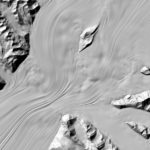
More Polar DEMs Released We’re so excited to announce our latest releases of high resolution elevation data for polar regions, … Continue reading Announcing Polar DEM Releases
Missed out on the newsletter via email? Sign up here! PGC Welcomes Stephanie Linde We would like to extend a … Continue reading PGC News & Announcements (December 17, 2021)
On Wednesday, December 1st, 2021 the Director of National Intelligence, Avril Haines, recognized the PGC for concerted efforts in understanding … Continue reading PGC Recognized by Director of National Intelligence
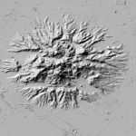
We’re expanding beyond the polar regions! Announcing EarthDEM – High resolution (2m!) time-stamped elevation data for non-polar regions. EarthDEM’s repeat … Continue reading Announcing EarthDEM!
Missed out on the newsletter via email? Sign up here! PGC EarthDEM Release COMING SOON! PGC User Survey Results + … Continue reading PGC News & Announcements (September 1, 2021)
Attention EVWHS / G-EGD Users: It has come to our attention that the National Geospatial-Intelligence Agency (NGA) is in the … Continue reading Attention EVWHS / G-EGD Users
This presentation has been recorded and is available here. In light of the Arctic and Antarctic field seasons cancellations and … Continue reading October 14th Webinar Science Speaker – Andrew Fleming