

Missed out on the newsletter via email? Sign up here!
PGC Welcomes Stephanie Linde

We would like to extend a warm welcome to Stephanie Linde, our newest staff member. She brings over ten years of GIS project management and consultancy experience. Stephanie has supported a wide range of stakeholders, scientists, and audiences in environmental data analysis, data visualization, and cartography. We’re thrilled to have her join our team!
PGC Recognized by Director of National Intelligence at
Vice President Kamala Harris’ First National Space Council Meeting

On Wednesday, December 1st, 2021 during Vice President Kamala Harris’ First National Space Council Meeting, the Director of National Intelligence, Avril Haines, recognized the PGC for concerted efforts in understanding the impact of climate change.
Our ArcticDEM and REMA data were highlighted, as well as our public-private partnerships, as examples of how we helped catapult the polar regions from one of the worst to one of the best mapped places on Earth in order to better track the rapid change.
Check out the video to learn more about the impact of our work and collaborations.
EarthDEM Data Release

ICYMI – We’re expanding beyond the polar regions! Last month we announced the release of EarthDEM, our high resolution time-stamped elevation data for non-polar regions.
The EarthDEM products are available to U.S. federal employees, U.S. federal contractors, and U.S. government-funded researchers. To gain access, users can submit an access request form and agree to an End User License Agreement (EULA). Once access is granted, DEMs can be searched and downloaded using NASA’s Commercial Smallsat Data Acquisition Smallsat Data Explorer tool.
We’re excited to see what users can discover using this vast dataset! Please visit the following links for more information:
Help us spread the word about #EarthDEM by sharing our posts on Facebook, Twitter, and Instagram.
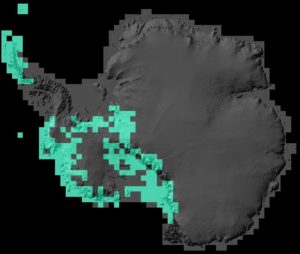
Antarctic Mosaic Update
In our 2021 survey, our Users asked for more frequent updates to our Imagery Viewers…and we’re delivering! Our team has focused efforts on improving high priority areas for our Antarctic Viewer update (highlighted in the figure on the right). The new 50cm imagery mosaics cover much of western Antarctica, the peninsula, and the Transantarctic range with imagery dated through August 9, 2021. The update will be live in the coming weeks. PGC’s Arctic Viewer updates will be completed in Spring 2022! Stay tuned! Arctic Tasking Requests
|


Check out the original PGC Newsletter post here.