

Missed out on the newsletter via email? Sign up here!
PGC Users Webinar Series: EVWHS for PGC Users
PGC is pleased to host the first of its PGC Users webinar series, EVWHS for PGC Users, on Wednesday, September 25, 2019 at 12-1 PM Central.
The National Geospatial-Intelligence Agency (NGA) has contracted with DigitalGlobe to provide the EnhancedView Web-Hosting Service (EVWHS), a viewer and web service that can deliver raw, pansharpened, and orthorectified imagery products. The usage and licensing of imagery within the EVWHS platform is the same as for imagery and products you receive from PGC, and can only be used for federally funded work. High-resolution imagery is copyrighted by DigitalGlobe, Inc. and licensed to PGC (and its users) through the NGA NextView license.
Webinar registration is open only to researchers and contractors working under an active federal-funding award number and are subject to approval. If you are interested in our webinar and are not sure if you are eligible to join or would like to request an EVWHS account, please contact us at pgc@umn.edu.
We will cover basic training topics such as interface and navigation, ordering archive imagery, creating alerts and more. Register at the link below:
https://umn.zoom.us/webinar/register/WN_DsA5QmupQm2XnWUIyTmQmQ
GeoMAP: Geological Mapping Update of Antarctica
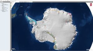
Last month at the 2019 International Symposia on Antarctic Earth Sciences in Incheon, Korea, the Scientific Committee on Antarctic Research (SCAR) and Simon Cox at New Zealand GNS Science released the world-first digital database of Antarctic geology, GeoMAP.
The international project catalogs every area of exposed rock by type and age on the continent derived from hundreds of paper maps and feature classification using GeoSciML data protocols.
Check out the web map with REMA base layer at https://data.gns.cri.nz/ata_geomap/index.html?map=Antarctic
SIO Global Bathymetry Model SRTM15+
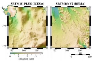
Scripps Institution of Oceanography has announced the latest iteration of their global bathymetry model SRTM 15 Plus.
The updated global elevation grid at a spatial sampling interval of 15 arc seconds combines multi and singlebeam measurements and re-tracked range measurement altimetry data. For completeness, the dataset will also include topography from ArcticDEM and REMA projects.
Read the accepted manuscript for more info.
2019 Interdisciplinary Antarctic Earth Sciences Conference & Antarctic Deep Field Camp Planning Workshop
The Organizing Committee for the NSF-supported 2019 Interdisciplinary Antarctic Earth Sciences conference (13-15 Oct) and the Antarctic Deep Field Camp Planning workshop (15-16 Oct) invite new and veteran scientists to discuss new scientific results and participate in community-wide discussions about science priorities and future field-based logistics hubs. Mentoring opportunities will be available for new Antarctic researchers and early career scientists. Both meeting and workshop will be held at Camp Cedar Glen, near Julian, California. The meeting is intended to provide a forum for recent Antarctic research, to facilitate the exchange of information, and to encourage interdisciplinary research in the Earth Sciences. The workshop is intended to identify key scientific research topics that will help determine the highest priority sites for potential multidisciplinary U.S. Antarctic deep field camp.
Abstract submission Deadline is August 23 *EXTENDED
Poster submission Deadline is September 20
Details and registration can be found by visiting the Antarctic Science homepage.
PGC Icebreakers
Meet the PGC team members that will be deploying this year to McMurdo Station, Antarctica. We have a couple new faces so here is how we started breaking the ice for you on getting to know them. Read about how they answered, “Whats’ a hobby you’ve always wanted to pick up but haven’t yet?”
 Steve Foga is returning for his second Antarctic deployment this season and has been at PGC for 2 years. Steve is a Topeka, Kansas native and a hobby he’s always wanted to pick up but hasn’t yet is playing piano and says, “I’m already pretty handy with a QWERTY keyboard” or he’d like to roast coffee beans (because who doesn’t need more caffeine?).
 Cole Kelleher is an ice veteran. This will be his eighth deployment to McM and has been at PGC since 2011 while he was earning his Master’s in GIS at the University of Minnesota. Although Houston, Minnesota is Cole’s hometown, he currently works remotely after relocating to Boulder, Colorado. He has always wanted to pick up woodworking but hasn’t….yet.
 Shane Loeffler is deploying for the first time this season and recently joined PGC. His hometown is Finland, Minnesota and says, “I want to be really good at bashing on a drum kit but I haven’t lived anywhere, yet, that would allow me to make that kind of racket. Perhaps I can find some pots and pans and a deep, remote crevasse that I can rig into a practice space while I’m down on the ice!”
 Erik Husby is deploying to the ice for the first time this year. He first started working at PGC since his undergraduate days and was hired as a full-time staff member after earning his Bachelor’s in Astrophysics and Computer Science with a minor in GIS in spring of 2017 . Erik’s hometown is Roseville, Minnesota and a hobby he’s always wanted to pick up but hasn’t yet is playing the guitar.
Blue Waters Extended to Produce Global Topography
Read the original PGC Newsletter post here.