
PGC Support Vignette: NSF-OPP #1111882
Overview
GNET seeks to “weight” the Greenland ice sheet with an unparalleled level of temporal and spatial detail. One branch of their work uses high resolution elevation models derived from stereoscopic commercial satellite imagery to enhance the picture of ice sheet mass-balance provided by the GRACE satellite gravimetric measurements. A finer scale offers the opportunity to account for both local ice variability and to calibrate the GRACE measurements, a crucial step in reducing the uncertainty of current mass change models and forecasts.
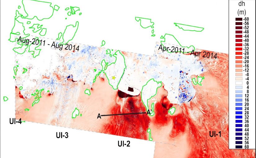
Between August 2011 and August 2014, Upernavik Isstrom lost up to 60m (red) in areas. GNET can identify local causes of regional variability using stereoscopically-derived DEMs calibrated with local ground stations (yellow star). Larsen et al (2016). Journal of Geophysical Research, 121.
Explanation of Support
PGC coordinated the collection and delivery of stereoscopic commercial satellite imagery over key regions of the Greenland ice sheet. From satellite tasking and imagery curation to software development and data distribution, PGC’s activities secured a new dataset and analytical workflow that allowed the GNET investigators to address questions left unanswered by the datasets currently available.
Impacts & Implications
Science: Detailed models of dynamic glacial phenomena
Stereoscopically derived digital elevation models (DEMs) have a higher spatial and temporal resolution than other elevation sources. In conjunction with the GNET ground installations, the absolute accuracy of these DEMs drops to less than a meter. Volumetric measurements made using these data can capture fine-scale phenomena: outlet glacier thinning and calving, seasonal cycles of accumulation and volume loss, and the effects of abrupt draining and filling of subglacial and supraglacial lakes.
A mix of satellite and airborne data capture the collapse and recharge of a large subglacial lake in northeast Greenland. Willis et al (2015). Nature, 518.
Broader Impacts of Support
Implications: Increasing the accuracy of ice mass measurements
GRACE measurements cannot fully discern the source of mass changes occurring at Greenland. Variability in the Earth’s upper mantle makes direct measurement of ice volume impossible without a correction factor. Small changes in the correction factor, the Glacial Isostatic Adjustment (GIA), have a big effect on estimates of the volume of Greenland’s ice cap.
Using high-resolution DEMs, GNET investigators can apply elastic corrections to the GNET GPS site motions, increasing the accuracy of the GIA correction for Greenland. This critical correction to GRACE data allows researchers to more precisely constrain observed mass changes.
Read more PGC Support Vignettes here. Want your work to be featured in a vignette? Send us a message.