Quantarctica Version 3 Released
Quantarctica, a free GIS for Antarctica, releases Version 3 with hundreds of GIS layers.
Hello! Login

Quantarctica, a free GIS for Antarctica, releases Version 3 with hundreds of GIS layers.
Commercial satellite imagery users, please read! Important changes effective immediately.
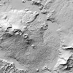
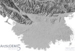
ArcticDEM Release 6 adds much of Russia and Scandinavia. ArcticDEM now covers 97% of the Arctic.
PGC’s ArcticDEM project was awarded in the HPC User Innovation category.
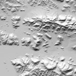
More, more & more! Fifth release adds more data than ever before including: Eastern Greenland, Yukon Territory, Northwest Territories, Nunavut, … Continue reading ArcticDEM Release 5
The National Center for Supercomputing Applications (NCSA) at the University of Illinois at Urbana-Champaign released their 2016 Annual Report. PGC’s Paul … Continue reading ArcticDEM Featured in NCSA Blue Waters [video]
The organizers of PEARC17 (Practice & Experience in Advanced Research Computing) today announced the keynote speakers for the conference in … Continue reading Paul Morin invited as PEARC17 Keynote Speaker
PGC’s Remote Sensing Scientist Claire Porter was recently featured in an interview for the University of Minnesota’s College of Science … Continue reading UMN Alumni Spotlight on PGC’s Claire Porter
About SETSM The Surface Extraction with TIN-based Search-space Minimization (SETSM) algorithm, is the first fully-automatic DEM extraction software specifically designed … Continue reading SETSM 3.1.0 Open Release
Overview ArcticDEM is an NGA-NSF public-private initiative to produce a high-resolution, high quality, digital surface model (DSM) of the Arctic … Continue reading ArcticDEM Release 4: Updates and New Regions

![ArcticDEM Featured in NCSA Blue Waters [video]](https://www.pgc.umn.edu/files/2017/05/post-news-ncsa-arcticdem-square-150x150.jpg)