
More, more & more!
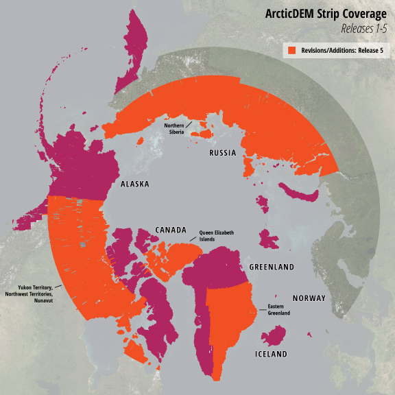
Fifth release adds more data than ever before including: Eastern Greenland, Yukon Territory, Northwest Territories, Nunavut, and Northern Siberia
RELEASE 5: UPDATES
The ArcticDEM team is excited to announce the largest release of data to date, more than doubling the number of available strip DEMs, mosaic tiles, and geographic coverage area of all releases thus far combined. Release 5 adds 33,169 2m posting time-dependent DEMs and 3,799 additional 2,500 square kilometer mosaics at 5m resolution. This brings the total number of available 2m DEMs to 53,178 – covering over 51 million square kilometers – and the total number of 5m mosiac tiles to 1,703, now covering 65% of the Arctic.
EXPLORE DATA
ArcticDEM data are available for online browsing and download. Visit the ArcticDEM page to see the updates in this release and download bulk data.
ABOUT ARCTICDEM
ArcticDEM is an NGA-NSF public-private initiative to produce a high-resolution, high quality, digital surface model (DSM) of the Arctic using optical stereo imagery, high-performance computing, and open source photogrammetry software.
Upon completion, ArcticDEM will encompass all land area north of 60° north latitude including all of Greenland, the State of Alaska, and the Kamchatka Peninsula of the Russian Federation. The project data releases began with Alaska on September 1, 2016, and will continue to other regions in the Arctic on a quarterly basis.
STAY UPDATED
Click here to subscribe to occasional ArcticDEM updates via email.
Read the original PGC Newsletter post here.