
In this guide
Imagery Processing Options
Last Updated: October 4, 2023

Glossary of parameters that PGC requires when processing imagery including file formats, projections, orthorectification, and other options.
Overview
After acquiring imagery from data providers, it is usually necessary for the user to perform a series of processing operations before the data is ready to be utilized for analysis or mapping purposes.
This processing can be both time and compute intensive, and unnecessarily increases the workload of the user.
To this end, it is PGC’s goal to provide products that will adequately and efficiently help its users carry out their scientific research or logistical services
Therefore, PGC’s User Services team is ready and willing to perform preprocessing operations on imagery so that it is ready to use upon delivery.
Because these processing operations will differ from user to user and from project to project, please work with your PGC point of contact to determine custom specifications for your imagery.
If the user prefers to perform their own preprocessing operations, PGC is always happy to provide the raw imagery files as well.
Raw Imagery
PGC receives imagery as NITFs (National Imagery Transmission Format), which was developed by the U.S. Department of Defense as a system to store and transfer digital imagery products.
Read the NITF specification from NGA
This format does very well compressing large image files with which it bundles important metadata.
Although most GIS software packages can open a NITF, the high compression creates difficulty when opening and analyzing the images.
It is recommended to export the images to another format before using them.
Imagery Processing
Due to the challenges accompanied with using NITFs, PGC provides a number of additional processing options.
Users should work with their PGC point of contact to determine the ideal processing parameters so that they receive the best product for their needs.
Reprojection
The NITFs that PGC receives are unprojected, i.e. in the WGS 1984 Geographic Coordinate System (EPSG:4326).
However, when PGC performs preprocessing, the imagery will be reprojected into a projection based on the geographic region containing the imagery.
Unless otherwise specified by the user, PGC defaults to the projections outlined in the table below.
Keep in mind that no map projection is perfect and that there will always be some level of distortion.
You can read more about map projections here
| EPSG Code | Name | Area of Use | Datum |
|---|---|---|---|
| 3031 | Antarctic Polar Stereographic | Antarctica | WGS84 |
| 3413 | NSIDE Sea Ice Polar Stereographic North | Greenland | WGS84 |
| 3338 | Alaska Albers Equal Area Conic | Alaska | NAD83 |
| Varies | UTM Zones 3-21 N | Alaska and Canada | NAD83 |
| Varies | UTM zones 1-59 N/S | Worldwide | WGS84 |
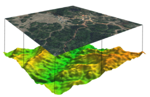
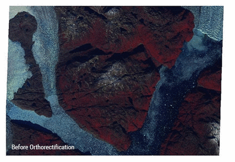
Orthorectification
The raw NITFs that PGC receives come georeferenced, meaning that the imagery is tied to latitude and longitude coordinates.
However, in its original state, the imagery is not georectified, meaning that the imagery has not been adjusted to account for distortions caused by the nadir angle and the Earth’s terrain.
These issues can be accounted for during a process called orthorectification, which uses a digital elevation model (DEM) and information from the sensor (RPC model) to stretch the image and remove these distortions.
This creates a planimetric image at every location with consistent scale across the image.
Bit Depth
The bit depth of an image pixel refers to the range of values that a particular raster file can store, otherwise known as the radiometric resolution of an image.
The values are based on the formula 2n where n is the pixel depth. For example, an 8-bit raster file can have 256 unique values, ranging from 0 to 255.
Whereas the raw NITF files come as 11 bit raster files, PGC generally processes each image into either an 8-bit raster or a 16-bit raster.
An 8-bit image sufficiently distinguishes between features on the ground and has a much smaller file size. 8-bit images are good for visual analysis or basemaps.
A 16-bit image has a much larger file size but is usually preferred when performing analysis and raster operations on the pixels, as the full range of radiometric values can be used. 16-bit images are good for remote sensing analysis, where the values must be preserved.
Please speak with your PGC point of contact about your project specific needs if you are unsure of what bit depth what option would be ideal.
Read more about raster bit depths from Esri here
Spectral Bands
Optical satellite imagery often is referred to as multispectral, meaning it has multiple layers, or bands, of pixel values that are combined to display the energy reflectance in different ways depending on how the image will be used.
True color imagery, for example what you see in Google Earth, mimics the way that our eyes interpret reflected energy by combining red, green, and blue bands.
Infrared bands, on the other hand, are extremely useful in identifying change and health of vegetation on the ground.
Alternatively, imagery can also be collected and displayed using only a single band, which is displayed using a grayscale.
This is referred to as single band or panchromatic imagery, and can often be collected with a higher spatial resolution than multispectral imagery.
Read more about spectral bands from Esri here.
Maxar’s various satellites have different capabilities specific to the spectral bands that each sensor collects.
Note that each each multispectral image has an associated panchromatic image and they are often delivered together.
Histogram Stretch
An image’s original digital number (DN) values may not be distributed evenly across the histogram, utilizing the full range of possible values. This might result in an dark image with reduced contrast.
By applying a histogram stretch, on an image, the DN values are spread across the full range of values enhancing the image’s ground features.
Although there are various stretching methods, PGC does not apply any during preprocessing. Instead, the user can choose their preferred method of histogram stretching in their GIS or image editing software.
Radiometric Correction
When light enters the Earth’s atmosphere, it is partially scattered before reaching the ground by particles or atmospheric gases, affecting the true reflectance value of objects on the ground.
Radiometric correction is the process offsetting or accounting for these reflectance errors.
Depending on the user’s preference and the geographic location, PGC commonly applies one or two radiometric correction techniques to a set of imagery during the pre-processing phase.
Top of Atmosphere Reflectance (TOA) is the reflectance measured by the sensor as it is flying higher than the earth’s atmosphere. Thus, contributions from clouds, aerosols or gases may be included.
PGC has found that this method is preferred in areas that require increased contrast, such as between rocks and ice. Reflectance values are expressed as a percentage (0-1). When delivered in 8-bit form, those values are scaled from 0-200. When delivered in 16-bit form, they are scaled from 0-2000.
Modified reflectance uses additional information such as date, sun angle, or climate to help account for atmospheric disturbances. This method generally works will in areas with lots of vegetation and exposed, ice-free ground.
Output File Formats
When processing imagery, the PGC will output the files to an easy-to-use format.
The default format used by PGC is a GeoTIFF, but imagery can be output to other file formats such as JPEG 2000, ENVI, or HFA if preferred by the user.
Advanced Imagery Products
In addition to the standard pre-processing options, PGC provides a number of additional imagery products, such as pan-sharpening, mosaicking, and stereo-derived elevation models.
Pan-sharpening
Pan-sharpening is a process that combines the panchromatic bands of an image with the multispectral bands. The resulting product will have the resolution of the panchromatic band, while using the multispectral bands to give the image color.
Mosaicking
PGC can also mosaic multiple images into a single, continuous raster file, much like you would see in Google Earth.
Additionally, PGC has built an Image Viewer that already includes mosaicked imagery for most of Antarctica, Alaska, and Greenland. These mosaics can be seen in a web viewer, connected to through as a WMS, or downloaded in tiles.
Much of Maxar’s archive includes imagery collected in stereo. Using NASA’s Ames Stereo Pipeline (ASP) software, PGC can use this imagery to produce stereo-derived Digital Elevation Models (DEMs).
Detailed documentation of Ames Stereo Pipeline available on GitHub
Depending on data availability, these elevation models can be customized to your area of interest or time period.
Summary
In this Guide, we’ve covered:
- NITF (raw imagery) Specifications
- Reprojection, orthorectification, correction, and file conversion
- Pansharpened, mosaicked, or stereo advanced imagery products