
In this guide
Imagery Archive
Last Updated: November 10, 2025

PGC’s imagery archive contains millions of scenes for the polar regions. Learn where, why, and how the PGC collects imagery.
Geographic Coverage
The PGC imagery collection primarily covers the polar regions.
The polar regions (by our definition) consist of all of Antarctica and most land masses south of 60°S, as well as land masses in the Arctic north of 60°N and some extended regions including Kamchatka in Russia and southeast Alaska.
More recently, PGC’s archive also contains imagery for most of the land represented by the Randolph Glacier Inventory, featuring high-altitude, ice-covered terrain all over the world.
PGC has assisted earth scientists with many other projects, including imagery to study volcanoes, landslides and other large-scale terrain changes, and ocean/shoreline changes worldwide. However, these cases are on a limited basis, negotiated with ad hoc agency agreements.
By the Numbers
By the end of 2016, PGC’s optical, high resolution imagery collection contains more than 8.5 million unique Maxar scenes.
Related Guide: MAXAR Satellite Constellation
The collection occupies more than 3,500 terabytes of disk space, over 2,000 of which is available internally via file-server to our production clusters.
The area represented by PGC’s collection is enough to cover the Earth four times over, thanks to temporal depth extending back to the early 2000s. Since PGC’s inception, the collection has grown by an average of seven terabytes per week.
New Imagery Collection
Overview
The PGC works with the National Geospatial-Intelligence Agency (NGA) to coordinate annual collections of high-resolution imagery over the Arctic and Antarctic regions from Maxar including the WorldView-1, WorldView-2, WorldView-3, and GeoEye-1 sensors.
PGC submits a coordinated tasking plan for the Arctic in late January and for the Antarctic in late July.
The timing of these tasking submissions corresponds to when sufficient sunlight and sun angles permit optical imagery collections to begin in each region.
Tasking is not PGC control over the satellite on a daily basis. Maxar ultimately controls what is collected and when.
Note: Only under extreme circumstances will this tasking plan change after it has been submitted as it is designed to meet the needs of all science and logistics groups equally.
Tasking Parameters
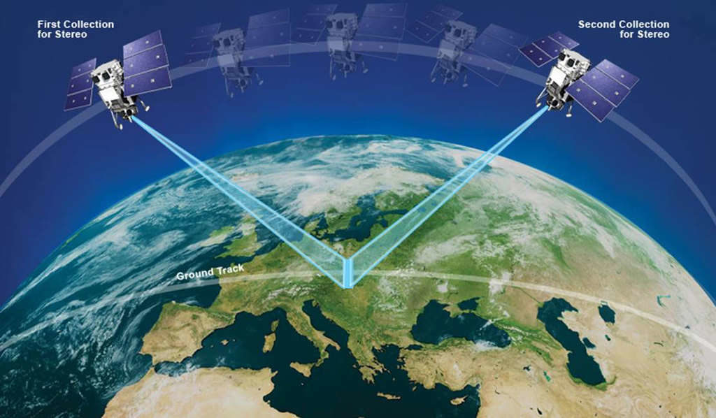
Monoscopic imagery is collected in a single swath. In-track stereoscopic collections are two image swaths collected at two intervals over the same extent, just seconds apart.
Panchromatic is grayscale imagery collected at native resolution, with pixel sizes between 30cm and 50cm depending on the collection angle. All Maxar satellites that PGC tasks have a panchromatic band.
Multispectral imagery contains several bands (e.g. red, blue, green, near-infrared, etc.) that are lower resolution, ranging from 1.2m to 2.4m, depending on the sensor and collection angle.
Frequency refers to how often a single point target can be collected by a satellite. While each satellite may have a revisit time over a location of just 1 to 2 days, in practice the sensor is limited to how often it can actually image a certain target (see limitations below).
For monoscopic collections, the highest collection frequency PGC can request is once every two weeks.
For stereo collections, the highest frequency to collect a target is once every month.
Unfortunately, this does not guarantee any target will be collected at the requested frequency, but rather serves as guidance to the Maxar collection planners who coordinate our tasking requests among the hundreds of others submitted by various customers and entities.
Limitations
There is no guarantee that any target location you specify will be collected.
This is due to natural conditions (e.g. clouds, fog, shadows, sun-angle), commercial competition, satellite capacity, or nearby sites that have higher priority.
However, because PGC manages a large amount of tasking in the polar regions for our core users, we coordinate all the requests and submit a plan that maximizes imagery collection potential for all users.
At this time, the PGC is only able to submit point targets on behalf of our users for image acquisitions. We cannot accept polygonal or linear targets.
There may be other constraints involved with tasking solicitations that will be communicated at the appropriate time (e.g. minimum distances between points).
Please note that it is almost impossible to have imagery collected on a specific day, or even +/- 3 days. It is best to select a frequency and a date for attempted collections.
Delivery
Unless there is a unique circumstance (e.g. search and rescue, logistics priority), imagery will typically be available in the PGC archive within three to six months of collection.
You can then submit a request through your PGC point of contact to receive the imagery.
Related Guide: Working with PGC
Please do not expect imagery to be available on demand, particularly for large volumes of data. The nature of our workflow to order, ingest, catalog, index, and archive significant quantities of imagery requires several months to complete.
That being said, we encourage our users to stay in communication with us regarding the status of their tasking submissions.
If you want to periodically check what has been collected over your tasking points on your own, we recommend using Maxar’s ImageFinder web application.
Planning Your Tasking
First, accurate coordinates are crucial. The average collection swath for an image is only 17km wide, so if your coordinates are off, the collection will be off.
Second, the fewer constraints you put on your collection request (e.g. date ranges, frequency, or band requirements) the more likely it is to be acquired.
Valid requests are for logistics planning (e.g. field camps, aircraft landings, site reconnaissance) or for science analysis (remote sensing analysis, time-series, etc.).
If you’re unsure of what you’re interested in, reach out to your PGC point of contact to discuss.
Submitting Tasking
In advance of each Arctic/Antarctic field season, your PGC point of contact will email you with a spreadsheet and instructions for submitting tasking requests.
The README tab in the spreadsheet will describe the satellite parameters you are able to select for the locations you would like collected.
Then, use the TARGETS tab to list your sites and save the table with your last name in the filename.
The spreadsheet can then be submitted back to your point of contact and we will review for anything that may need to be adjusted.
Please note that if you have not created an account with PGC and not received elevated privileges you will likely not receive a tasking solicitation email. Please refer to Working with PGC to begin your working relationship with the PGC!
Acquisition and Ordering
The PGC systematically assembles orders for polar satellite imagery every four to six weeks (on average).
Images with over 20% cloud cover are generally not ordered unless specifically requested.
Regardless of whether an image was acquired as a result of a specific PGC tasking submission or any other collection means, you can typically assume we will order an image automatically if it falls within the polar regions.
Note: This applies to new acquisitions only
Orders are submitted incrementally to our fulfillment channels in batches of 1,000 to 3,000 Catalog IDs.
As we receive the images they are inventoried and transferred to permanent fileserver storage.
The PGC produces an internal spatial index of images (a “footprint”) that contains the image metadata and their location on the fileserver. This footprint allows the PGC staff to display, query, and retrieve images for delivery to our users.
Unfortunately, this process is not instantaneous. From the acquisition of a satellite image to it becoming available to the user from PGC, the entire process can take between three and six months.
Other channels exist to obtain low-volume imagery orders more quickly, so please contact your PGC point of contact if you have an urgent need for an image that is not already in the PGC archive.
Summary
In this Guide, we’ve covered:
- PGC’s archive contains millions of polar satellite images
- New imagery is collected through tasking submissions
- Workflow for tasking, acquisition, and ordering