
In this guide
Requesting Imagery
Last Updated: October 4, 2023

Detailed workflow for searching for satellite imagery and requesting it from the PGC.
Maxar Archive Search
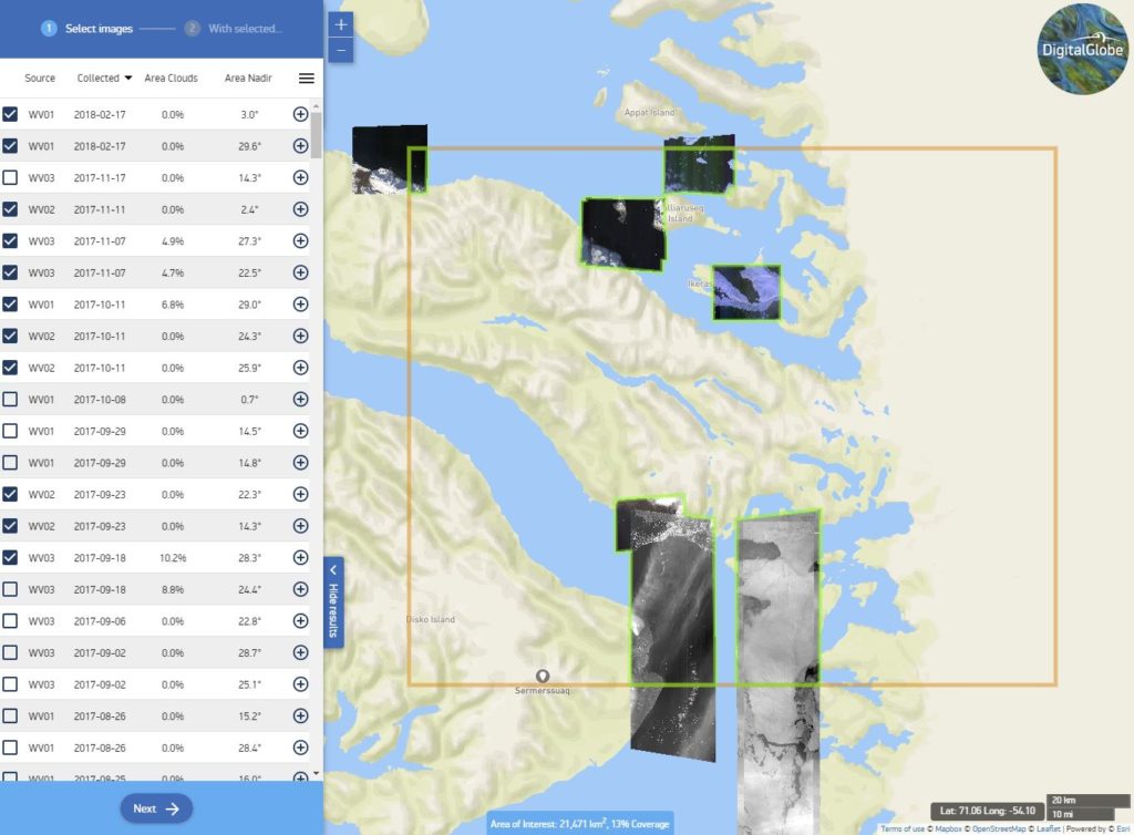
The most effective way to search what has ever been collected by Maxar is through their Discover online application.
This utility allows you to search the entire catalog through a map interface. You can narrow your search by searching for a place-name, entering a CatalogID, entering coordinates, or by uploading a polygon (shapefile, KMZ).
Maxar Discover URL: https://discover.maxar.com
Once you have established the area of interest (AOI), filters can be applied to retrieve only images that match your interestes (e.g. product type, cloud cover, date range, off-nadir angle, sensor).
Hint: By default, panchromatic imagery is unchecked. To enable panchromatic imagery in the search, choose Filters > Image Type and check PAN
After you initiate the search, a sidebar will appear with your results with some default scenes selected and displayed on the map. This table can be sorted by any of the criteria that you have established. Select (checkbox) the imagery that you are interested in.
When you have images selected, click “Next” to see various options for export. To submit imagery to the PGC, click the “Download Selected Products” button and choose “Shapefile.” PGC will need this shapefile to cross-reference the archive and ensure we have the proper metadata for your request.
Note: You cannot download imagery through the Maxar Discover application. It is only a portal for browsing the imagery collection.
A .zip file, which includes the index/footprint shapefile, will download. You may email this .zip file directly to your PGC point of contact.
Requests to the PGC
There are several ways to make a request for PGC imagery.
You Select the Imagery
Experienced users may prefer to search Maxar’s archive themselves using the Discover application (see above) to determine the images they would like to request. Ultimately, PGC will need the image Catalog ID (or a list of Catalog IDs) in order to identify, retrieve, and deliver the imagery.
A Maxar Catalog ID is a 16-digit text/number string that uniquely identifies each image collected by one of the satellites. Catalog IDs can be sent to your PGC point of contact through email, as a text document or attachment, or as shapefiles that contain the Catalog ID as an attribute field.
PGC Selects the Imagery
Other Users may prefer to have PGC staff select candidate images on their behalf. It is important to be as detailed as possible when describing your image requirements.
Some important criteria to describe include:
- Area of interest (described in coordinate boundaries, location with radius, or provided as a GIS point, line, or polygon file)
- Date or year range (from X to X)
- Seasonal criteria (e.g. only summer images, etc.)
- Acceptable cloud cover percentage
- Acceptable snow cover
- Acceptable off-nadir angle
- Spectral mode – Panchromatic or Multispectral
- Multispectral bands – is 8-band or 4-band multispectral imagery needed?
Your PGC point of contact can assist with any questions or make recommendations based on your intended use.
Summary
In this Guide, we’ve covered:
- Navigating Maxar’s Discover tool
- Requesting scenes by a list of Catalog IDs
- Request parameters for an area-of-interest