
In this guide
Citation and Publication Approval
Last Updated: October 3, 2023

Imagery citation and public use approval requirements (e.g. publications, posters).
Imagery Citation
Anytime Maxar commercial satellite imagery is used it must include a copyright. The copyright is attribution to the vendor acknowledging their contribution and source data.
The copyright verbiage (below) is simple. Replace [20YY] with the year of the image acquisition date. In the case that there are images from multiple years, use the current year.
Imagery © 20YY Maxar
You may replace the © symbol with “copyright” or “(c)” if necessary
There are several different ways which the copyright can be included. Here are a few common examples. Regardless, the copyright verbiage is always required.
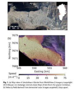
In a caption
For most academic publications, reports, and posters, the copyright statement, included for each image, will suffice. The caption should never be separated from the figure.
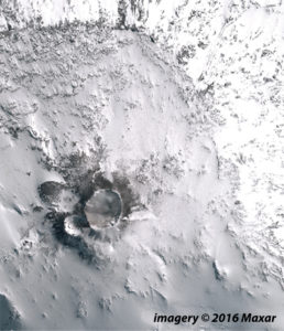
On the image
When an image is “stand-alone,” you may place the copyright text directly on the image itself. Having the copyright on the image itself ensures the statement is always with the image.
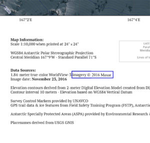
In data credits
If the imagery is used on cartographic products (e.g. maps), you may opt to include the copyright statement in the data source listings of the map margins.
CONTROLLED WEB APPLICATIONS
Imagery in an online GIS application, website, or web service must have access control for your team and adhere to the EOCL license. These applications must not be public-facing and must include copyright statement visible on the map / app.
Acknowledging the PGC
National Science Foundation (PGC’s primary funding source) policy requires researchers to acknowledge NSF support in all publications, web pages, and media interviews.
PGC has developed an extensive acknowledgement policy to walk you through our expectations. Follow the link below for the complete policy.
Visit PGC Acknowledgement Policy
Note: The PGC Acknowledgement Policy is also delivered as a document with every imagery delivery.
Approval for Public Release
In 2022, the National Reconnaissance Office (NRO) issued a policy for EOCL-licensed imagery in coordinated public releases.
Detailed information about the license and frequently asked questions can be found here.
As a commercial satellite imagery user via PGC, you must get approval from NGA to publish that imagery (which is licensed under the EULA – EOCL license) in publicly-accessible materials. Approval is required for, but not limited to:
- Academic Journals (any access)
- Posters and Presentations
- Websites, Blogs, and Social Media
- Any other format with public access
Products Included
SUBJECT TO COPYRIGHT, EOCL LICENSE, AND NGA APPROVAL
- Imagery: Raw or processed imagery with georeferencing information
- Imagery Derived Products: Digital elevation models (except REMA and ArcticDEM), satellite imagery maps, reduced resolution images, imagery screenshots
NOT SUBJECT TO COPYRIGHT, EOCL LICENSE, AND NGA APPROVAL
- Derived Products: Non-imagery datasets or images such as line drawings, analysis results (e.g. NDVI, Land-Use Classification, GIS features extracted from imagery)
If you are unsure, for any reason, where your “product” falls within these categories, we urge you to contact us for further guidance.
Essentially, any product that retains a form of the original pixels (which inherently have a commercial value), must be approved by NGA if it is going to be released publicly.
Failure to adhere to this requirement will result in loss of future imagery access (for you and potentially others). Please note, regardless of the copyright and public release requirement, all deliveries from PGC must adhere to the PGC Acknowledgement Policy.
Approval Process
You must contact PGC if you are to use imagery or imagery derived product in any of the formats above which will be in the public domain. PGC will then forward your objectives and imagery use to NGA for approval.
You must send this to PGC for review well before your material is released in the public domain (print, online, presented). For peer-reviewed publications, we recommend sending for approval when your manuscript is in review.
The review process, from submitting to PGC to approval, will normally take less than 24 hours. PGC has streamlined this process so you don’t have to!
1. Download and complete the Submission Form Template (Word document).
IMAGERY FOR PUBLIC RELEASE – TEMPLATE
2. Email the completed submission form and pre-published material (draft manuscript, image, figure, caption, etc.) as attachments to pgc@umn.edu with “Imagery for Public Release – [Your Last Name]” in the subject line.
3. PGC will forward to NGA for approval immediately.
4. PGC will notify you upon approval, unless further information is needed.
Note: The published material must still include the proper copyright and acknowledgements (see above sections).
Why?
PGC often receives the question, why is this so complicated?
PGC’s goal is to make imagery citation, acknowledgement, and approval for public release as simple as possible for our users. PGC has successfully navigated the satellite imagery license and built relationships with the vendors so that researchers can do science with this incredible resource.
The requirements as listed above are simply to acknowledge the effort and resources provided by all parties. A failure to do so substantially risks the access to imagery for civilian science.
We encourage you to reach out to PGC with any questions about the license, Maxar, NGA, or the approval process.
Summary
In this Guide, we’ve covered:
- Citation requirements for Maxar imagery
- Acknowledgements the PGC
- NGA Imagery for Public Release approval process