
Elevation
Terrain datasets collected from spaceborne and airborne sensors offered as Digital Elevation Model(s)
Want to stay updated?
Subscribe to our mailing list!
Introduction
Elevation data is a digital representation of the Earth’s terrain. Data can be represented as points (x,y,z) or in a gridded format (raster).
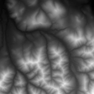
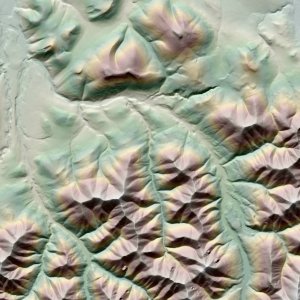
Digital Elevation Models (DEMs) are gridded raster where each pixel of the image has a value, the elevation above a model of the Earth (WGS84 Ellipsoid, for example). The size of each rectangular pixel (e.g. 2 meters x 2 meters) is referred to as the spatial resolution.
Elevation data can be collected in many ways, including airborne laser sensors (LiDAR), photogrammetry from aerial photography or satellite imagery stereo pairs, or surveying.
Elevation Datasets
Stereo-derived Elevation Models
ArcticDEM
BACKGROUND
The ArcticDEM project is a joint collaboration between the PGC and many U.S. agencies to produce a high resolution Digital Elevation Model for the entire Arctic. PGC has a dedicated page for ArcticDEM and more information can be found there.
Go to ArcticDEM.
ACCESS DATA
Visit the ArcticDEM page for downloads, documentation, and more information.
REMA
BACKGROUND
The Reference Elevation Model of Antarctica (REMA) project, led by Ian Howat at The Ohio State University was funded under National Science Foundation award #1543501 in 2016. The first version of the complete pan-Antarctic digital elevation model was released in September 2018.
REMA is constructed from stereoscopic, sub-meter resolution imagery collected by the WorldView satellite constellation. The high spatial and radiometric resolution of the imagery enables photogrammetric digital elevation model (DEM) extraction over low contrast terrains such as snow, ice, and shadows.
These DEMs have horizontal and vertical offsets of up to several meters that can be reduced to the DEM relative accuracy of 0.2 meters with a single ground control point. REMA uses available control points from ground and LiDAR surveys to register individual DEMs and optimized, least-squares co-registration to provide control between overlapping DEMs over large regions.
REMA has postings of 2 meters in areas of interest, and accuracy better than 1 meter.
EFFORTS
The project lead, Ian Howat at the Byrd Polar and Climate Research Center heads development. Data processing is facilitated by the Blue Waters supercomputer at the National Center for Supercomputing Applications at the University of Illinois at Urbana-Champaign. The PGC provides satellite imagery, manages DEM production, and freely disseminates the final data products.
For more information, visit the REMA page.
ACCESS DATA
Visit the REMA page for downloads, documentation, and more information.
EarthDEM
BACKGROUND
The EarthDEM Project provides high-resolution terrain maps for non-polar regions. Individual EarthDEM DSMs can be used to provide measurements of elevation change through time. The mosaic products offer a seamless, high-resolution reference model to serve as the foundation for further geospatial analysis and modeling.
Current licensing restrictions limit the release of non-polar DEMs derived from Vantor imagery to federal employees/contractors and federally-funded researchers.
Go to EarthDEM.
ACCESS DATA
Visit the EarthDEM page for downloads, documentation, and more information.
Custom Elevation Models
Custom DEM production is no longer provided to PGC core users due to restructured operations under PGC’s NSF cooperative agreement.
Refer to the Stereo Elevation Models guides for more information.
ACCESS DATA
Contact your User Services point of contact or fill out a Data + Services Request.
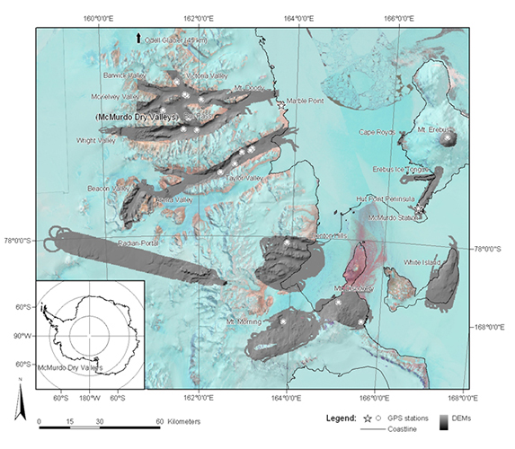
McMurdo Dry Valleys LiDAR
Antarctic LiDAR and Airphoto Campaign (2014-2015)
BACKGROUND
Under National Science Foundation award #1246342, Principal Investigator Andrew Fountain (Portland State University) led a campaign to collect high resolution LiDAR and aerial photography for the McMurdo Dry Valleys in Antarctica. The campaign was conducted by the NSF’s National Center for Airborne Laser Mapping (NCALM). The campaign flew for several weeks in December 2014 and January 2015.
More information on instrumentation, coordinate systems, and accuracy can be found in the collection report.
The dataset can be cited from the following publication:
Fountain, A. G. et al: High-resolution elevation mapping of the McMurdo Dry Valleys, Antarctica, and surrounding regions, Earth Syst. Sci. Data, 9, 435-443, https://doi.org/10.5194/essd-9-435-2017, 2017.
EFFORTS
The LiDAR is available in two formats, composite grids and LAS point clouds.
Gridded elevation models are organized by region and downloadable in 32-bit floating point GeoTIFF format. The GeoTIFFs are a composite, meaning the individual flight line point clouds have been co-registered and mosaicked into one 2 meter horizontal resolution grid for each region. Therefore, there is no date provided for these files as they are a composite from multiple flights and passes.
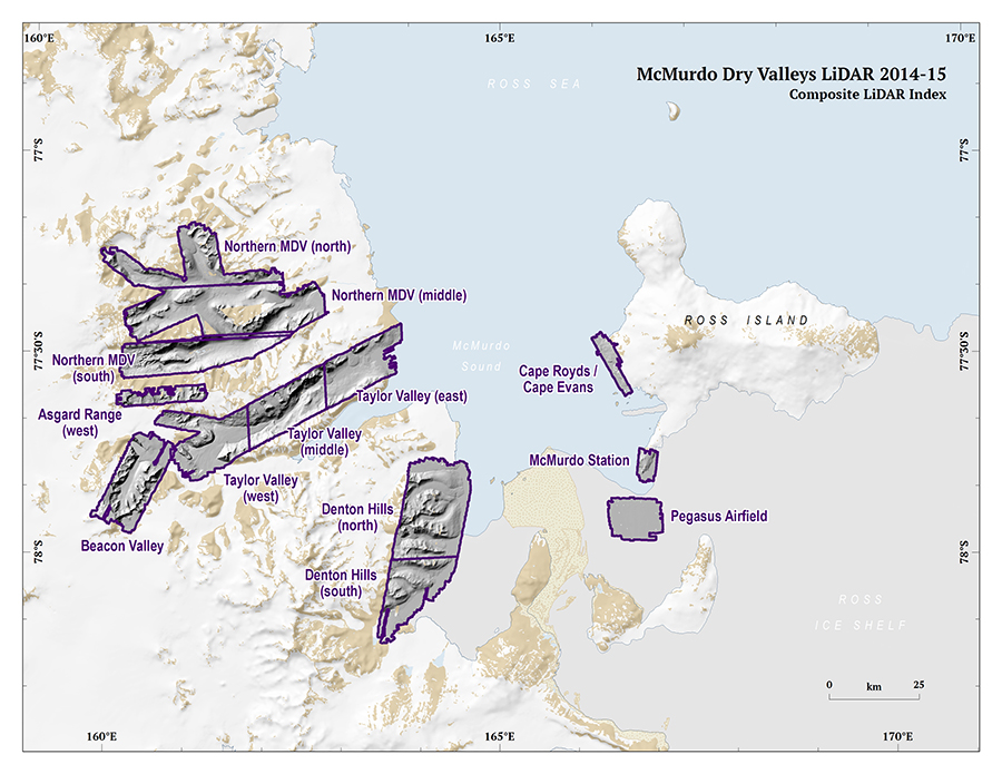
LAS point cloud files are available in 1 km by 1 km grids. Each grid contains thousands of points and has varying point density. The downloadable LAS files are organized by region, like the gridded rasters, Please note, at this point, it is not possible to extract individual flightlines from the LAS point clouds, due to how the data was delivered to PGC.
ACCESS DATA
DOCUMENTATION
Airborne Topographic Mapper (ATM) Campaign (2001)
BACKGROUND
In December 2001, an joint NASA, NSF, and USGS campaign collected LiDAR using the Airborne Topographic Mapper (ATM) laser altimetry system in the McMurdo Sound, Antarctica region. In all, 18 sites were collected including Taylor Valley and Mount Erebus.
The raw point cloud data was gridded into a 2 meter resolution Digital Elevation Model.
Read more on the project website.
EFFORTS
The PGC, although not involved in data collection, processing, or archiving has the original gridded files available on our server for download. Each gridded DEM is available in a .zip file for quick download and use.
Looking for More?
The PGC has compiled a list of other polar elevation data resources from a variety of agencies.